
Israel National Trail – Maps

As technology evolves more mapping options will become available for hiking the Israel National Trail. Several possibilities are suggested here.
Above: The Israel National Trail along the Netanya promenade.
Google Street Maps

In preparing for a hiking trip to Israel and the INT, we use several sources for maps. The first is Jacob Saar's guide, featured below. Another is the excellent selection of maps from Wikiloc, which follows the description of the Israel National Trail Offline Maps by Noam Gal.
Israel National Trail – Jacob Saar
See our “Resources in English” page for full information, including a 20% discount for orders placed at the UK bookseller Cordee.
This website is intended for anyone who speaks very little or no Hebrew, but I would be remiss if I did not mention the following two options, which should be accessible to anyone who is very comfortable with maps and can read names of locations in Hebrew at a basic level, at the minimum.

1. The Society for the Protection of Nature in Israel (SPNI) sells high quality topographical maps of the entire country of Israel (pictured above), with emphasis on all of the hiking trails. If you are intending to explore more of Israel than the INT, you will want to be familiar with this valuable resource.
These maps are available for purchase online at this site (along with INT tee shirts). The link for the English version of the website does not provide a way to order the maps online, so this option is indeed for those who are comfortable with at least a basic level of Hebrew (or who use Google Translate to get the gist of the page's content). They are available at a discount for supporting members of the SPNI.
Every two weeks in Israel, the Israel Trails Committee gives a briefing on hiking the Israel National Trail (in Hebrew). The SPNI maps are also available at a discount at these briefings.
2. The Israel Hiking Map on Open Street Map (OSM) is an open-source project. This map is also primarily in Hebrew, but if you cross-reference to maps with cities designated in English, you can find your way from point to point. A few of the map items are labeled in English, as in the example below, but not enough to make it fully readable for the non-Hebrew-speaker. This map is excellent for determining terrain, elevation change, places where you will be challenged, as well as helping you locate road crossings and other points of reference. As with the SPNI maps, the OSM maps attempt to cover all of the hiking trails in Israel, not just the INT. Using this and the Wikiloc maps (below) you can do a virtual hike through Israel. As will Google maps, you can drag the OSM map up and down and sideways to follow the trail all the way through Israel.

The first time you open the Israel Hiking Map, it takes you to a map page located west of the Jerusalem area. On subsequent visits it returns to your last visited location. There are many other features that have been recently added to this site. OpenStreetMap is a longstanding open-source project that proves the value of crowdsourcing. The map information is collected and edited by volunteers, much like a wiki, and is constantly being improved.
Israel National Trail Offline Maps – Noam Gal
From developer Noam Gal's GitHub page: "I have created an offline map file along the trail, using data from OpenStreetMaps (OSM), and the Hiking Map Rules of the Israel Hiking Map." Last updated February 2017.
I have not yet reviewed this site's resources, but it appears to be potentially very useful for those of us who hike with GPS devices, or who survey the terrain with Google Earth. If you have tested these files, please contact me and tell me about your results.


A good online reference can be found at wikiloc.com. A search for the "Israel National Trail" brings up several detailed trip descriptions. The elevation profile above (the INT near Kefar Giladi) is an example of some of the information which can be found at this site. Information includes elevation changes, distance, accumulated uphill and downhill, estimated time, photos, and difficulty level.
A search on this Wikiloc site for "Shvil Yisrael" gives 65 returns. Some people also spell it "shevil israel" on Wikiloc, which produces 195 results. (These are different at phonetic transliterations from Hebrew.) Until this site, IsraelTrail.net has a collection of GPX tracks to offer for download (a project that is in the works), this is your best bet for finding them on an English-language site. Check to be sure the listing is for "hiking" and not for "biking." Also, be aware that these tracks are uploaded by users from their own travels, including any detours they may have recorded off of the trail.
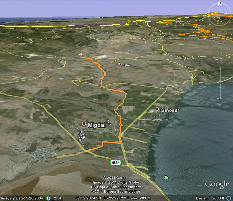
On the wikiloc website, look for the link to the Google Earth imagery of sections of the Israel National Trail.
Below is a sample of Section 7, near Qaddarim, Northern District, near the Kinneret (Sea of Galilee).
Follow this link to go to directions on how to create your own virtual tour of the terrain of the Israel National Trail using Google Earth.
Yes, that describes a tedious process and there are better ways to find a map of the trail.